
Climate change is an all-encompassing issue that has societal, economic, and ecological impacts. As a small island, Nantucket is particularly vulnerable to the effects of climate change. Accelerated rates of erosion and increased flooding events are in large part influenced by changes in sea level rise and the occurrence of more frequent and intense storms. Resilience means building the ability of a community to “bounce back” after hazardous events such as hurricanes, coastal storms, and flooding – rather than simply reacting to impacts. Accordingly, the Town of Nantucket hired the consulting firm Arcadis to create the island’s first comprehensive Coastal Resiliency Plan (CRP). Click here to learn more about the CRP. The mission of the Coastal Resiliency Advisory Committee is to “work with the Coastal Resiliency Coordinator in the development, oversight, and implementation of a Coastal Resiliency Plan for the Town of Nantucket to address the impact of climate change and sea level rise.” The Land Bank has been an active member of this committee since 2022.
As a significant landowner on Nantucket, the Land Bank is proactively engaged in researching and implementing resiliency solutions. Our waterfront properties and other valuable natural resources such as wetlands, salt marshes, and dunes make the Land Bank uniquely positioned to help manage and adapt to these climate-induced challenges through nature-based solutions and hybrid green/gray infrastructure projects.
As a public open space organization, we aim to create public access through the design and installation of resilient green spaces. Read below for a few examples of Land Bank projects that have been designed with both public access and resiliency in mind.
Easy Street Park
 The Easy Street Park was designed with the knowledge that this area was subject to regular flooding inundation – flooding that was only expected to increase in the future. Given these existing conditions, the park needed to be designed to withstand flooding. The park’s elevated boardwalk and carefully designed topography left pockets of space for water retention, and mounded garden beds rest on top of a layer of sand facilitating drainage of residual flood waters. These raised mounds are full of native and flood-tolerant vegetation, which has the capacity to withstand coastal weather events and provides a pocket of wildlife habitat in an otherwise heavily developed area. In addition to the ecosystem services this park provides, its downtown waterfront location and ample bench seating make it an enjoyable amenity for residents and visitors.
Washington Street & Consue Springs
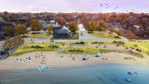
Francis Street Beach Plans (SCAPE)
The Washington Street corridor, one of Nantucket’s key transportation routes, is vulnerable to rising sea and ground water levels, as well as increased stormwater flooding. Positioned along the shoreline of Nantucket Harbor, it also provides abundant recreational opportunities for people and valuable coastal habitats.
The Land Bank has partnered with SCAPE, the Woods Hole Group, ReMain Nantucket, and the Town of Nantucket to conceptualize holistic improvements to this area that will transform this stretch of downtown beach for future generations.
Lily Pond
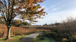 Following heavy rain, water flows directly into Lily Pond. This parcel essentially serves as the catch basin for a major watershed that lies just west of downtown and plays an essential role in holding and filtering stormwater before it is discharged into the harbor. As severe storm events are expected to increase with climate change, the filtration function of these wetlands is critically important. The Land Bank has partnered with the Horsley Witten Group to develop a restoration plan for Lily Pond, with the main goals of improving stormwater retention and filtration using nature-based solutions, removing invasive species, and enhancing the visitor experience at this park. It is estimated that when this project is complete it will have increased the filtration capacity of this wetland for stormwater entering the harbor by approximately thirty percent.
Easton Street
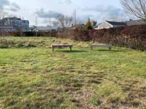
The Land Bank’s Easton Street property experiences frequent flooding during precipitation events and is also a key drainage area for stormwater entering the harbor. Accordingly, we plan to create a rain garden in this park. The park was designed to improve this property’s ability to hold and filter stormwater, in addition to providing additional downtown green space. Rain gardens are depressions that lie below the level of their surroundings – they are intentionally designed with native perennial plants that have robust root systems which absorb water and filter out pollutants from stormwater runoff.
For more information about rain gardens and how you can build your own, click here: Build it and Clean Water will Come! A Rain Garden Guide for Homeowners.
Madequecham Beach
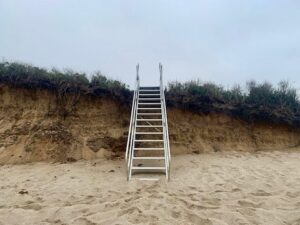 Sometimes resilience is as simple as making management decisions that are easily adaptable and flexible to facilitate ongoing use. For example, in 2021 we installed aluminum stairs at Madequecham Beach in response to the accelerated erosion along this coastline. The aluminum stairs are a versatile solution in that they are easily removable and adjustable as the bank continues to shift. They help to minimize human disturbance on the dunes and accomplish the goal of continued public access.