
September marks Nantucket Climate Change Awareness Month, a time to recognize both the challenges our community faces and the opportunities we must take to build a more resilient future. On Nantucket, the impacts of a changing climate are not abstract; they’re already visible along our shorelines and roadways. Washington Street, a vital transportation corridor that connects downtown to the rest of the island, is increasingly vulnerable to flooding during coastal storms and high tides. As sea levels rise due to climate change, these disruptions will only grow more frequent, threatening not only daily life but also emergency access. In response, the Town of Nantucket and the Nantucket Land Bank along with their sponsors, Remain Nantucket, Lambert Foundation, and Nantucket Community Foundation have come together to create the Washington Street Resilience Framework Plan, a long-range plan to adapt to predicted flood conditions using both nature-based solutions and coastal flood infrastructure.
The Woods Hole Group developed sea level rise projections for the project area based on the MA Coastal Flood Risk Model, which uses the state’s high sea level rise scenario. The model predicts that shallow flooding will impact Washington Street daily via multiple flood pathways as soon as 2050, and by 2070, high tide flooding will impact most of Washington Street.
 2025 Nantucket Climate Change Summit Poster Presentation
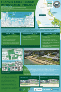
The first phase of the Washington Street Resilience Framework Plan is the Francis Street Beach Improvement Project. The 1.7-acre Francis Street project area includes several Town and Land Bank owned parcels. The low elevation of this location establishes a direct pathway for floodwaters to enter Washington Street during significant storm events. The goal of the project is to mitigate flooding, create accessible waterfront experiences for people, and reduce the risk of damage to critical infrastructure from sea level rise caused by climate change.
Though still in the concept planning phase, this project will include dunes or other nature-based solutions designed to reduce flood risk paired with an elevated ADA multi-use path, rain gardens, and recreational assets such as an overlook deck and a kayak launch. This design will improve beach access for the public, enhance the downtown waterfront experience, and improve Washington Street’s capacity to adapt to rising seas.
In this long-term planning process, the next phase will focus on developing a preferred direction to advance to schematic design. This will build on community and stakeholder feedback, as well as findings from ongoing technical studies. If you have any ideas or comments, we would love to hear from you. You can call or email our office at (508)-228-7240 or info@nantucketlandbank.org or visit us at 22 Broad Street.